
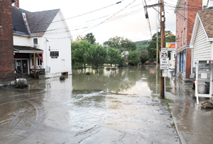

Waterbury village was absolutely hammered by flooding from Tropical Storm Irene in 2011.
Now, the community is trying to figure out rules that would minimize flooding, but not cripple development.
The municipal planning commission held a public hearing Monday on proposals for new flood regulations that would affect construction in the town and village.
The proposals would:
• Prohibit builders from raising the base flood elevation level of properties within the 100-year floodplain, which includes areas along the Winooski River and elsewhere susceptible to flooding in the rare catastrophic storm expected once in a century.
• Require builders to elevate the first floor of new homes and commercial buildings larger than 5,000 square feet to 1 and 2 feet above the expected flood level within the 500-year floodplain, with variances for historic buildings. Owners of smaller buildings would be permitted to fill basements to elevate the first floor for lower flood insurance rates, providing the overall topography grows no higher in elevation.
Now, Waterbury regulations allow builders to raise the base flood elevation level by as much as 3 inches.
“The policy is to allow site fill, providing base flood elevation is either maintained or decreased at the site,” community planner Steve Lotspeich said at the hearing. “It’s basically a no-net-rise policy and that’s how the regulations are structured.”
• Require builders to get certification from an engineer that grading and excavation projects will not raise the overall base flood elevation level of a property — a requirement that might have saved a lot of heartache for Waterbury residents Kathryn and Robert Grace, whose properties on South Main Street were flooded during Irene.
“As you know, we have been in a four-year legal battle regarding the placement of illegal fill in the floodplain behind our house by Keurig Green Mountain and Pilgrim Partnership,” Kathryn Grace told the commission. “The dirt was initially placed there in early September 2010 and not removed until April 2013 after we won a hard-fought legal battle via the Act 250 Commission.”
The Graces say the fill severely worsened their Irene flood damage.
The Graces say they had no flood insurance to cover the $300,000 in damage to their home and two rental properties just north of Demeritt Place, which lie just outside of the 100-year floodplain. After receiving a small federal grant for their primary residence, the Graces spent $100,000 on legal fees and a hydrology study to sue the partnership, rejecting a settlement offer two years ago.
The legal fight inspired state Rep. Rebecca Ellis, D- Waterbury, to introduce a Statehouse bill in February that would require the automatic awarding of legal fees to homeowners seeking recompense for such breaches of environmental law.
Historic, or not?
The proposed municipal flood regulations in Waterbury would also regulate redevelopment and additions, Lotspeich said. Projects bringing “substantial improvement” affecting most of the property’s value would require that the lowest floor be at least a foot above the 500-year floodplain.
However, the new regulations would allow the town’s development review board to grant variances for historic buildings. “A non-historic building would have to be elevated, but historic structures substantially improved do not have to be elevated, although there are other conditions,” Lotspeich said.
The planning commission proposes to require that such historic buildings be “reasonably safe from flooding,” with utilities elevated and foundations floodproofed.
Lotspeich said the new State Office Complex now under construction in Waterbury exemplifies the new standards for commercial construction, with a basement filled with concrete and a first floor rising a foot above the 500-year flood threshold.
Yet, town officials also specified that the development review board could grant permission for homeowners to fill as much as 10,000 square feet of property — about a quarter-acre — without hiring an engineer to certify no net rise in the base flood elevation level.
“The idea is if you want to go out and regrade your yard or do some drainage work, and you can demonstrate adequately to the administrative officer that you’re not going to elevate, you don’t have to pay for an engineer to do a study,” Lotspeich said.
Velocity, directionality
Although the issue might seem simple, Robert Grace told planners at the hearing that fill may also influence flooding in other ways.
“We learned in our costly hydrology studies that fill does increase elevation in a single-dimensional study, but if you go to a three-dimensional study, fill can increase velocity and it can increase directionality,” Grace said. “It’s my understanding that you could plus or minus the fill, but you could still change the velocity and directionality, which basically did a lot of damage to our property.”
The Graces say the directionality of the fill placed near their property helped to create a moat around their home, indicating the problem remains more complex than previously thought.
Yet predicting how fill, beyond its level of elevation, influences the flow of floodwater remains a complicated matter, according to commission member Jeff Kompanion.
“If you put any structure, including two houses, next to each other, you’re going to increase velocity and directionality,” he said. “There’re some things you can affect and some things you can’t.”
Lotspeich said planners would consider comments on the proposed regulations again at a public hearing in mid-April, after alerting the state and adjacent towns.
(1) comment
+”Prohibit builders from raising the base flood elevation level of properties within the 100-year floodplain, which includes areas along the Winooski River and elsewhere susceptible to flooding in the rare catastrophic storm expected once in a century.”
“100-year floodplain” does not mean that a flood is expected once per century. Rather, it means that in any given year, there is a 1% chance of a flood. This translates to approximately a 63.4% chance of one or more 100-year floods occurring in any 100-year period.
I’m concerned that this misperception gives people a false sense of security about development in the flooodplain.
Welcome to the discussion.
Log In
Keep it clean. Please avoid obscene, vulgar, lewd, racist or sexual language.
PLEASE TURN OFF YOUR CAPS LOCK.
Don't threaten. Threats of harming another person will not be tolerated.
Be truthful. Don't knowingly lie about anyone or anything.
Be nice. No racism, sexism or any sort of -ism that is degrading to another person.
Be proactive. Use the "Report" link on each comment to let us know of abusive posts.
Share with us. We'd love to hear eyewitness accounts, the history behind an article.