
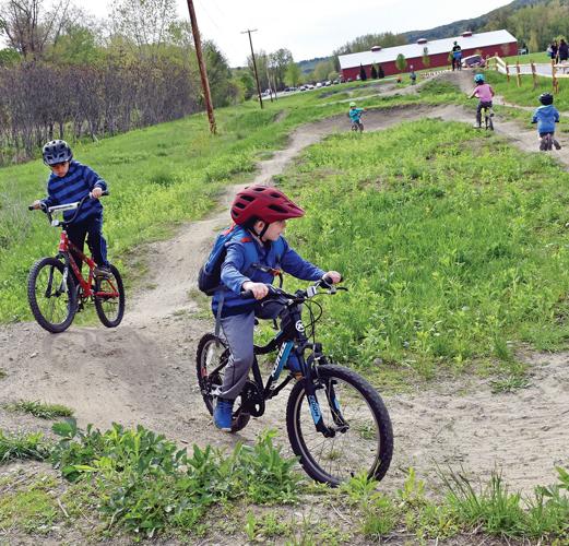

In the last two decades, mountain biking has exploded across Vermont, and the Stowe-Waterbury-Morrisville area is one of the state’s hotspots.
The Vermont Mountain Bike Association is up to 28 chapters now, and its members contributed more than 30,000 hours of time a year to maintain trails and build even more of them, working with public and private landowners.
In this area, more and more riders are throwing a leg over the saddle to take on new trails, and statewide plans are developing to connect trails networks from Killington to Stowe in a project known as Velomont.
“I think it’s just a matter of time before mountain biking is to summer as skiing is to winter in Vermont,” said Caleb Magoon, a member of the Brewster River Mountain Bike Club and the owner of sporting goods stores in Waterbury and Morrisville.
Velomont is a long-range collaboration among six mountain bike associations, including the Mad River Riders, Waterbury Area Trails Alliance and Stowe Trails Partnership.
The Mad River Riders intend to create a connector trail through the Dowsville Block of Camels Hump State Park to Crossett Hill in Waterbury, providing easy access from there to either the Perry Hill trails network or the Little River State Park trails, where a new 3-mile stretch was added in 2016 and 20 more miles of single-track is in the works.
The added single-track would include a sustainable trail connection to Cotton Brook, where it would link with Stowe trails.
From there, the Stowe Trails Partnership hopes to partner with Trapp Family Lodge to link its trails into that network.
While there are no plans to extend the connectors any farther north into Lamoille County, advanced riders can already make it through to Morrisville and on to Hyde Park.
Magoon knows a group of adventurous guys who have made the trek through Cady Hill and the Town Loops on to Sterling Valley and Mud City Loop, up over Cote Hill to the Cady’s Falls trails, with just a few miles of dirt road in between.
Over the years, there has been talk of building a formal path between Stowe and Morrisville, Magoon said.
“It’s something I want to get back to and pursue,” he said.
For now, because a lot of trails are already available for advanced riders, both on and off the map, the focus is on establishing sustainable, beginner-friendly trails.
One style that’s costlier to build, but fun for everyone to ride, is the flow-style trail, Magoon said.
That’s what’s trending right now, and what was most recently constructed in the Perry Hill and Little River networks on the Waterbury end of the network.
They’re smooth, rolling, machine-built tracks with a lot more berms and doubles that can be jumped or rolled over at a relatively slow pace. All the roots and rocks have been removed from these trails.
A few years ago, Magoon and Ryan Thibault of Stowe helped construct a beginner flow-style trail on Cricket Hill in Hyde Park, behind Lamoille Union High School.
The Brewster River Mountain Bike Club just took over maintenance of that small trail and hopes to put up signs, and to develop a few more miles of intermediate and beginner trails on the other side of the road on land owned by the school district.
The other Brewster River trails are in Jeffersonville, Cambridge and Underhill. One system, known as the Valley Trails, isn’t mapped and crisscrosses mostly private property in Underhill, where the club must balance between having trails that people ride, but not so many riders that private landowners are disrupted.
The Valley Trails are mainly used by local residents who hear of them through word of mouth.
Volunteering on trail work days is a good way to learn the Valley Trails network, says Brewster River club director Mike Timbers.
“We obviously won’t police it, and allow nonmembers to ride those trails, but we have to be careful” how many people are using the private land, Timbers said.
A new and expanding network between Smugglers Notch and Jeffersonville village, known as the Midland trails, will cover public land conserved by the Vermont Land Trust, and will be mapped and open to the public.
The Midland trails network covers only about 3 miles thus far, but the goal is to expand that network to connect the village with Smuggler’s Notch Resort.
Other trails networks in the area include the Hardwick Trails, with access from Hazen Union High School, and the Stowe trails in Adams Camp and Sterling Forest.


(0) comments
Welcome to the discussion.
Log In
Keep it clean. Please avoid obscene, vulgar, lewd, racist or sexual language.
PLEASE TURN OFF YOUR CAPS LOCK.
Don't threaten. Threats of harming another person will not be tolerated.
Be truthful. Don't knowingly lie about anyone or anything.
Be nice. No racism, sexism or any sort of -ism that is degrading to another person.
Be proactive. Use the "Report" link on each comment to let us know of abusive posts.
Share with us. We'd love to hear eyewitness accounts, the history behind an article.