


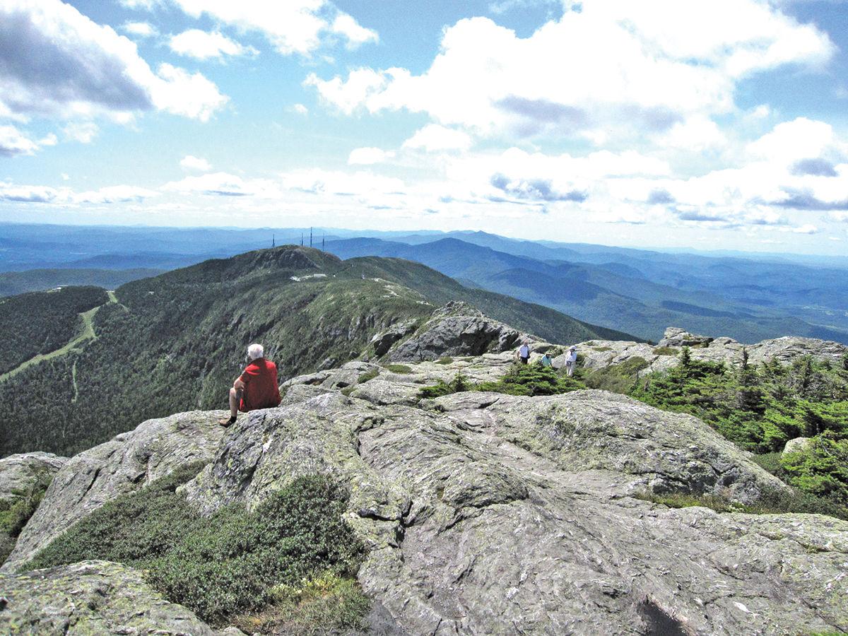
Mount Mansfield could be considered the face of Vermont — it’s the state’s highest peak at 4,393 feet, plus its topography resembles the profile of a man in repose. It’s pretty easy to pick out of a lineup, but what about the other mountains in our area?
Here’s a rundown of some of the peaks (and valleys) you might spot while out scouting the beautiful fall foliage.
The Green Mountain State gets its nickname from the many mountains in Vermont, including the eponymous range that runs mostly south to north through Vermont.
The state’s name literally means “green mountains” — “verts monts,” en Francais — but it’s just as beautiful in multicolored autumn splendor, or blanketed in white in the winter.
The Long Trail, Vermont’s 272-mile “footpath in the wilderness,” follows the main ridge of the Green Mountains from border to border, crossing Vermont’s highest peaks. It was built by the Green Mountain Club in the first few decades of the 1900s, and inspired the creation of the Appalachian Trail, which coincides with the Long Trail in the southern part of Vermont.
The Green Mountain range (part of the Appalachian Mountains) also extends about 250 miles into Massachusetts and Connecticut, where it’s known as the Berkshires, and into Quebec, called Monts Sutton.
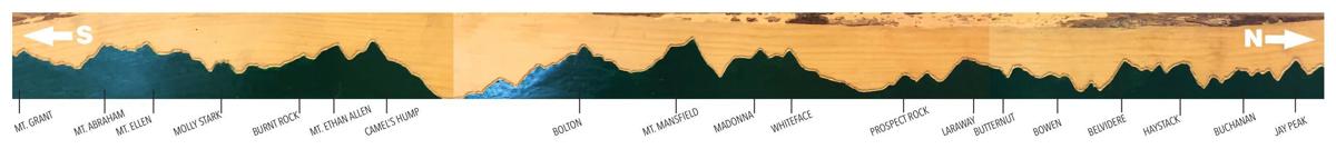
Stowe is home to the highest peak on the range (and in the state), so here’s a look to the north and to the south from Mansfield.
The south-facing view from the Chin — the highest peak of Mount Mansfield, and the highest point in Vermont at 4,393 feet — offers up a majestic vista of the Green Mountain Range. Bolton, Camel’s Hump, Mt. Ethan Allen and more are visible; check out our guide below for more peak identification tips. The carving pictured below can be found at the Green Mountain Club in Waterbury Center, along with tons of information about the Long Trail.
• Mount Mansfield, 4,393 feet: The highest point (the “Chin”) is technically in Underhill, and the mountain extends into Stowe and Cambridge. There are about 200 acres of alpine tundra on Mansfield, which means it’s too cold and windy for trees to grow, so there is some unique vegetation to be seen there. The Toll Road is a great foliage trip, the steep road traversing from the Base Lodge to the “Nose” of the mountain.
Before snow falls, drivers can cross through Smugglers' Notch/Route 108, the winding mountain pass that separates Mansfield from Spruce Peak (known as Sterling Mountain on the other side), to get to Smugglers Notch Resort.
To the north
• Smugglers' Notch Resort in Jeffersonville consists of three mountains: Morse (3,376 feet), Madonna (3,640 feet) and Sterling (3,714 feet). The name harks back to the Prohibition era, when actual smugglers used the dense forest and caverns along the trail to transport illegal goods to and from Canada.
• Continuing northward, Prospect Rock in Johnson offers panoramic views of the mountains and the Lamoille River Valley. It’s a short (about 3 miles) but steep journey off, with a very pretty payout. Nearby are Laraway Mountain (about 2,790 feet) and Butternut Mountain (2,165 feet).
• Before you hit Jay Peak (3,968 feet), other Green peaks include Bowen (2,126 feet), Belvidere (3,360 feet), Haystack (3,445) and Buchanan (2,940 feet).
To the south
• Bolton Mountain — to the left of Mansfield, if you’re on the Stowe side; to the right if you’re looking at the range from, say, the drive on Interstate 89 from Burlington — stands about 3,700 feet, and the resort, Bolton Valley, notes that it has the highest base elevation among Vermont ski areas.

The iconic Camel’s Hump. Whitney Aldrich, owner of Axel’s Frame Shop and Gallery in Waterbury, is running a contest for the best photo of the mountain. Winners will be announced Nov. 16.
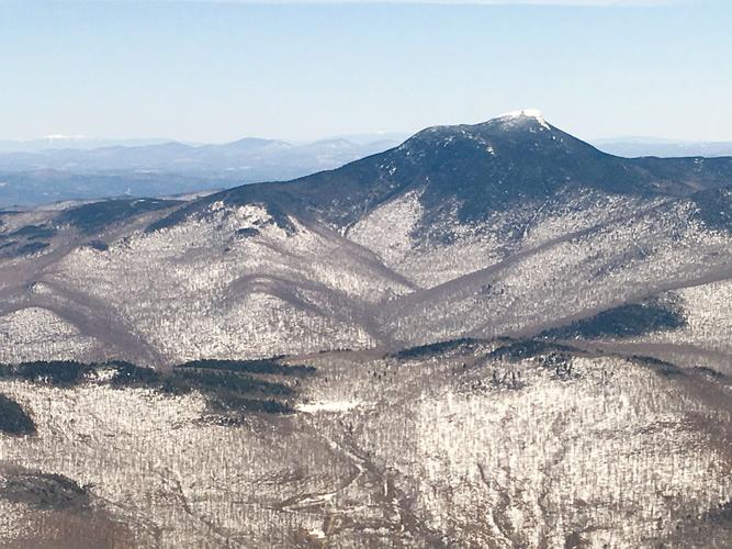
• Camel's Hump (4,083 feet), located in Huntington/Duxbury, is easily recognizable due to its distinctive and majestically lumpy shape, which was carved by the movement of glacial ice. The Geographic Names Information System lists 12 variant names, including Camel’s Rump, Catamountain and Couching Lion. There’s no ski resort on this peak, but there is some epic hiking to be had. From the summit, you can see Mansfield, Bolton, the Worcester Range, Jay Peak, Lincoln Peak, Mount Ethan Allen, Molly Stark Mountain and, on a clear day, all the way to Mount Washington in New Hampshire.
• Mount Ellen (4,083 feet) and Lincoln Peak (3,975 feet) are the two peaks of Sugarbush Resort. Camels Hump is considered the third-highest mountain in Vermont, but Mount Ellen, with a comparable elevation, boasts Vermont’s highest chairlift. The nearby Mad River Glen, on the backbone of the Green Mountains, has a top elevation of 3,637 feet.
• Mount Abraham (4,017 feet), or the colloquial Mount Abe, is the fifth-highest peak in the state. About six miles from Sugarbush, it can be climbed in the same day if your legs are feeling strong. The mountain, like Lincoln, is also named after the country’s 16th president, but in the 1880s it was known as Potato Hill.
• Keep going south and you’ll find the rest of the Presidential Range — Abraham and Lincoln, plus Nancy Hanks peak (after the president’s mother); Mount Grant (3,661 feet), Mount Cleveland (3,500 feet), Mount Roosevelt (3,580 feet) and Mount Wilson (3,756 feet). Unlike Mansfield or Rushmore, though, there are no faces to be seen.
Editor’s note: The exact heights of mountains are reported differently by various sources, but for Mount Mansfield, we go with the U.S. Geological Survey’s verdict of 4,393 feet.


(0) comments
Welcome to the discussion.
Log In
Keep it clean. Please avoid obscene, vulgar, lewd, racist or sexual language.
PLEASE TURN OFF YOUR CAPS LOCK.
Don't threaten. Threats of harming another person will not be tolerated.
Be truthful. Don't knowingly lie about anyone or anything.
Be nice. No racism, sexism or any sort of -ism that is degrading to another person.
Be proactive. Use the "Report" link on each comment to let us know of abusive posts.
Share with us. We'd love to hear eyewitness accounts, the history behind an article.