
Nearly eighty years ago, the last residents of Waterbury's Little River settlement abandoned their farms and businesses, turning the once large farming community into a ghost town.
Deep woods have reclaimed it but vestiges of 19th-century farm life remain, and this community's history awaits discovery by curious hikers. The old settlement is now preserved as part of the Little River State Park, located just north of the Waterbury Dam, and it features miles and miles of trails.
For over 100 years Little River was an active community. At one point, several businesses, five schools and as many as
50 families called this area home, but during the 1920s and early 1930s, the last of those families left for good. Today, one farmhouse, several other house and barn foundations, tools, machinery, family cemeteries, and other artifacts of daily 19th-century life exist as memorials to this old way of life.
The area's earliest settlers arrived in the late 1700s and were soon followed by other hearty, hard-working folks, according to author Patrick Yaeger, who researched Little River land records for his book, That Beautiful Vale Above The Falls.
The community's primary geographic features were the Little River (and its connecting streams) and Ricker Mountain, the flank of which became the center of the settlement. During its most active period, the Little River community covered about 4,000 acres. Most people lived north of today's Waterbury Dam in an area called the Ricker Mountain district. According to Yaeger, other groups of people lived in neighboring districts called Kelty Corners, Woodward Hill, Cotton Brook and Little River Road.
Most of the Little River residents were subsistence farmers who cleared the rocky, mountainside terrain to grow crops and to raise a few cows, goats, pigs and chickens. The thin mountain soil made farming difficult. Local industry, mainly a few sawmills, took advantage of plentiful wood supplies and access to waterways.
Fred Wood of Essex Junction confirms the community's hardscrabble existence. Wood's mother was born in Little River in 1910 and he remembers hearing stories of the struggles of daily life and the poor growing conditions.
Another Little River resident, Bernice White, 91, of Waterbury Center, remembers that it took enormous effort by every family member to work the family farm. They grew most of their own food and butchered the animals they raised. Even as a young girl, Bernice often slaughtered the chickens, and remembers her father washing the butchered animals in an old bathtub.
Even attending school proved a challenge. Bernice's mother took her on long wagon rides up the mountain to reach the district schoolhouse. In the winter they made the journey by sleigh, and each morning some children had to arrive early to start the fire.
By the late 1800s, families were leaving the Little River community. But some, like Charlie Ricker, clung to their farms as long as possible. According to Linda Kaiser, co-president of the Waterbury Historical Society, Ricker fought the town government from closing Little River's roads so he could remain on his farm. He lost the fight.
Eventually, most of the people lacked Charles Ricker's desire to stay, and one by one they abandoned their homes and barns to start lives elsewhere, leaving tools and other household items behind, some of which can still be seen today.
After major floods hit the Waterbury area in 1927 and 1934, the state began the Waterbury Dam project, and eventually bought all of the surrounding land.
During Little River's heyday, there were five schools, a Baptist church and a few sawmills. As the population dwindled, the schools closed, the mills fell silent, and church services stopped. Eventually, the church was moved to Stowe. It still exists today on Highland Avenue as a home.
During the mid-20th century, most of the abandoned homes and barns fell into decay. However, a single farmhouse on Ricker Mountain, formerly owned by the Goodell family, survived. Historian Linda Kaiser reports that her father, Henry Hough, and two friends bought the house for a hunting camp. The state later took ownership of the house and made it part of a new Little River State Park historical site. Local preservation efforts by Boy Scouts have helped to keep the house in decent shape, and at over 140 years old, the house still stands.
The best hike starts from the parking lot near the Nature Trail area. Head up the Dalley Loop Trail, made from old roads in the Ricker Mountain district. The trail is in generally good condition, but it is an uphill hike. Most people in average physical condition should have no problem, and in half a day see much of what the park has to offer.
Look for signs along the trails that detail historical information about the remains of many family homesteads. Brochures and maps available at the ranger station near the park's entrance offer additional information.
The Sawmill Loop Trail is an interesting side trip. The trail leads to the foundation of the former Waterbury Last Block Company sawmill. Around the sawmill's foundation you'll see one of the mill's two large
boilers, a truck chassis, tools and bandsaws.
You can also visit the Ricker cemetery and the grave of Florence Ricker, who was the last person buried here in the dead of a bitter winter exactly 75 years from her birth. Florence's husband's gravestone rests against hers, and surrounding the cemetery are white cedar trees. Not commonly found in Vermont forests, these trees were planted by the Rickers. According to History Hikes, published by the Vermont Department of Forests, Parks and Recreation's Agency of Natural Resources, the white cedars, or arborvitae, are known as the trees of life. The trees were planted to symbolically give life to the dead.
Another trail can be accessed from the end of Cotton Brook Road in Moscow, on the Stowe side of the Waterbury Reservoir. A longer trail with fewer historical remains, this hike traverses Little River's Cotton Brook district.
Much of the past remains intact at Little River and is ready to be discovered and enjoyed. Plan on at least four hours for any of the park's trails, be prepared for weather changes, and bring plenty of water.
Kevin Walsh, a freelance writer and photographer, has published over 40 articles and columns in various publications, including the Stowe Guide & Magazine. A civil trial lawyer in Boston, he lives with his wife and three sons in Weymouth, Mass., and for the past 16 years he has spent time each summer touring northern Vermont. He enjoys grabbing his camera gear, maps and notebook and exploring back roads and trails.


(1) comment
Hello Kevin, and thank you for drawing attention to the deep cultural history of Little River State Park. I am the returning Park Interpreter and lead hikes into the remains of the old settlement Thursdays, Fridays & Saturdays through the end of September. I also conduct a variety of other natural history programs and paddling trips on Waterbury Reservoir for all ages. Your article offers some intriguing leads to follow up on in order to gain more information about the residents of this area and I look forward to following up on them this season.
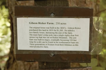
A couple of things about this article struck me. One was the photo of an old display slated for replacement. The park displays are old and rudimentary, with many fallen to ruin or simply gone. Most of those remaining have grammatical or factual errors and inconsistencies. This year, one of my tasks will be to begin the process of redesigning all the interpretive stops along the History Hike (Dalley Loop, Sawmill and Hedgehog Trails). The long-term plan will be to install professional, weatherproof displays like the ones in Groton State Forest.
The other thing is the book by Patrick Yaeger, "That Beautiful Vale Above The Falls." While it does have some good photographic reproductions, the stories within do not always concur with official historical records. Please know that much of the information contained within it was used and in some cases reprinted word-for-word *without permission* from a book entitled "The Settlement of Little River: History of Homesteads, Mills and Residents" by William G. Gove, copyright 1973, Vermont Dept. of Forests, Parks & Recreation. This official history can be viewed at Little River State Park by inquiring at the ranger station or the park interpreter.
A full schedule of Interpretive Programs at Little River State Park can be viewed online at the park's website http://www.vtstateparks.com/htm/littleriver.htm. It would be great to hear from anyone who knows of some historical facts, anecdotes or stories. The Park Interpreter can be contacted at 802-344-7103
Welcome to the discussion.
Log In
Keep it clean. Please avoid obscene, vulgar, lewd, racist or sexual language.
PLEASE TURN OFF YOUR CAPS LOCK.
Don't threaten. Threats of harming another person will not be tolerated.
Be truthful. Don't knowingly lie about anyone or anything.
Be nice. No racism, sexism or any sort of -ism that is degrading to another person.
Be proactive. Use the "Report" link on each comment to let us know of abusive posts.
Share with us. We'd love to hear eyewitness accounts, the history behind an article.