After December flooding forced the closure of a bridge that effectively bisected Stowe’s Quiet Path, town employees scrambled to build a new one a few hundred feet away instead of waiting a much longer time to go through local and state permitting processes.
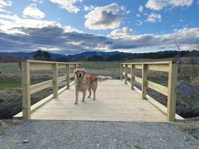
The new bridge connects Mayo Farm fields D and E and extends the path by a few hundred feet. According to town manager Charles Safford, it cost about $6,000 to build the new span, and the work was all done by town parks department workers, with materials purchased directly by the town.
“It saves a lot of money by doing it in-house,” Safford said last week during a selectboard meeting.
Safford said the idea had originally been for it to be a temporary bridge, giving people an alternate way to get their full circuit in while the town explored how, or whether, to replace the one that got washed out. However, selectboard chair Billy Adams said correspondence with people who use the path indicated they were satisfied and grateful for the quick build — not something that can always be said for projects of larger scope.
“It seems to be being received well by folks and users of the Quiet Path, and it would probably be prudent to make it a permanent location unless you tell us otherwise,” Safford said. “It’s outside of the flood zone, and less susceptible to getting wiped out. It’s a better location and narrower span and much more cost effective than trying to put it over something with a wire span.”
According to public works director Harry Shepard, the bridge, over an unnamed tributary of the West Branch of the Little River, had been undermined by frequent flooding. Shepard said flooding in mid-December was the second of “two flood events that exceeded classical 100-year flood levels,” with the first one the much more severe July flooding.
The discontinued bridge was originally built by former parks superintendent Bruce Godin, who created the Quiet Path in 1999 after people complained that walking along the popular paved Recreation Path was too distracting with all the cyclists and rollerbladers — Godin said the Stowe Reporter at one point referred to it as the “Wreck Path.”
Shepard said the span’s deck was built on top of steel beams supported on concrete blocks. But he said its location in the 100-year floodplain, combined with a couple of beaver dams in the area that blew out, caused “major scour,” and what used to be a 30-foot span is now, based on modern bridge-building guidelines, more like 60 feet.


(0) comments
Welcome to the discussion.
Log In
Keep it clean. Please avoid obscene, vulgar, lewd, racist or sexual language.
PLEASE TURN OFF YOUR CAPS LOCK.
Don't threaten. Threats of harming another person will not be tolerated.
Be truthful. Don't knowingly lie about anyone or anything.
Be nice. No racism, sexism or any sort of -ism that is degrading to another person.
Be proactive. Use the "Report" link on each comment to let us know of abusive posts.
Share with us. We'd love to hear eyewitness accounts, the history behind an article.