


The crowds are gone from the Waterbury Center State Park, but a late-spring landslide upstream of the popular Waterbury Reservoir at the center of the remains active.
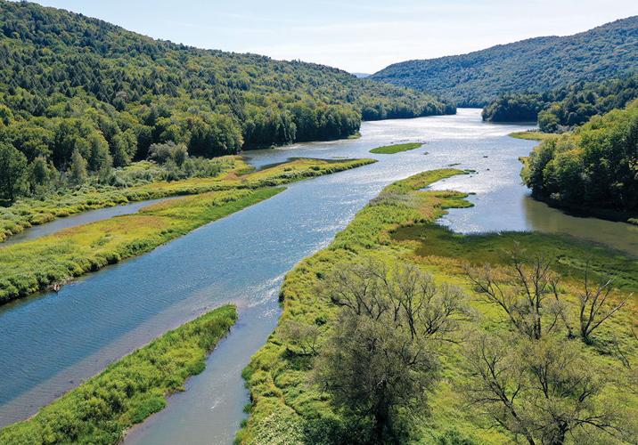
The landslide, which happened at the end of May, dumped tons of material into the Cotton Brook, turning it opaque and brown, and sending silt downstream where it formed a delta at the point where the river meets the reservoir.
It destroyed a portion of a recreation trail and closed off a road popular among hikers, bikers, walkers and snowmobilers as an alternate route between Stowe and Waterbury. Now, Cotton Brook Road is open again, but the state is still monitoring things.
The road, at the bottom of the landslide, was on the receiving end of tons of earthen debris, including fully mature trees yanked from their roots. Four months later, that road has reopened. Still, forest officials caution that continued observation and a new management strategy will be necessary to ensure public safety.
Completely eliminated in the slide, maybe forever, is a substantial part of Fosters Trail, which Walter Opuszynski, field recreation specialist with the state forests department, said was a popular alternative to get between Stowe and Waterbury without taking Route 100.
“The Fosters Trail landslide has completely changed the way we manage recreation in the Cotton Brook basin,” Opuszynski said. “The Fosters Trail allowed for an easily accessible loop and quicker recreation corridor connectivity between the towns of Waterbury and Stowe. It was also a safe alternative route for snowmobiles when forest management activities were taking place in the winter. Closure of Fosters Trail means we need to explore new ways and locations to re-establish this valuable recreation connector.”
According to Michael Snyder, commissioner of the Department of Forests, Parks and Recreation, most of the state parks shut down operations in mid-October, following the Indigenous Peoples Day holiday weekend, formerly known as Columbus Day. People can still get into the parks through stick season and winter, but they’re on their own — there are no facilities or staff.
The state is still asking people to stay away from some of the areas affected by the slide.
The Cotton Brook, from the landslide downstream to the reservoir, remains off limits until further notice. So do three remote campsites in Little River State Park — sites 16, 20 and 21 — even though that state park remains open until Oct. 27, a late closer compared to dozens of other parks around the state.
The landslide occurred on May 31 in the Cotton Brook area of Mount Mansfield State Forest. It sent 250,000 cubic meters of material down the slope and took out a 700-foot section of Fosters Trail, and temporarily dammed Cotton Brook.
To ensure public safety, Fosters Trail and Cotton Brook Road were closed for the summer, and a team of geologists was brought in to assess the landslide and determine if there were other locations in the Cotton Brook basin with the potential for a slide of similar scope and impact.
Fosters Trail will remain closed while state geologists continue to assess the distribution of glacial clays in the area. Those layers of clay, left over from ancient Glacial Lake Winooski, may have contributed to the slide in the first place — water got in between the layers of soil and just slid off the slippery clay.
The state’s team of geologists has been monitoring the landslide. Currently, it is considered active and another two acres could continue to slide down the bank toward Cotton Brook, although not posing enough of a risk to affect Cotton Brook Road again.
An initial assessment of other areas along the basin with similar slope characteristics did not show immediate signs of landslide activity.
“Future studies will help us better understand how the glacial clays that played a significant role in this landslide are distributed through the Cotton Brook basin,” said state geologist Marjorie Gale.
State officials will begin considering options for a new trail when they know more about locations where it will be safe to establish a new connector.
These closed locations can re-open once the Department of Forest, Parks and Recreation is confident that the landslide is no longer active and the soils associated with the delta have stabilized. Another change will be an extension of the spring mud season closure for the Cotton Brook Road. This closure could be dependent on the amount of rain the area receives, as spring rains saturating soils contributed to the landslide being triggered.
Updated information about the landslide can be found on the Vermont Department of Environmental Conservation website’s “landslide” page and the Vermont State Parks website.


(0) comments
Welcome to the discussion.
Log In
Keep it clean. Please avoid obscene, vulgar, lewd, racist or sexual language.
PLEASE TURN OFF YOUR CAPS LOCK.
Don't threaten. Threats of harming another person will not be tolerated.
Be truthful. Don't knowingly lie about anyone or anything.
Be nice. No racism, sexism or any sort of -ism that is degrading to another person.
Be proactive. Use the "Report" link on each comment to let us know of abusive posts.
Share with us. We'd love to hear eyewitness accounts, the history behind an article.